 |
|
1928
|
|
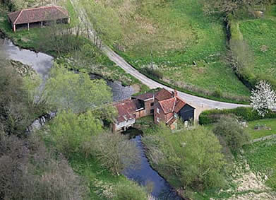
Blickling Mill
River Bure |
|
|
1928
|
|
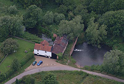
Blickling Mill
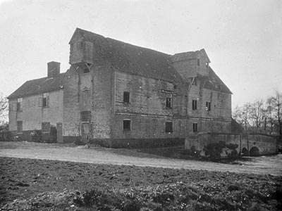
belonged to the Blickling Estate, which in 2007 is owned by the National Trust.
The north west chimney in the mill house is inscribed IS 1779. This would
have been James Savory and it could well also be the date the mill was
rebuilt for the final time. The house was extended in the 1820s, possibly coinciding with the
accession of John Savory to the family Business in 1827. The house was
extended again in 1860. |
 |
|
26th
October 2002
|
|
Records show that in the late 1700s Blickling watermill was worked in conjunction with Oulton_postmill, almost certainly by James Savory. Oulton_postmill stood on the common land just on the Oulton side of the parish boundary with Itteringham and was built c.1780. All three mills are shown on Faden's map of 1797. |
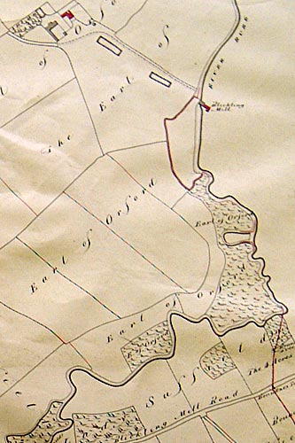
Blickling Mill 1559 |
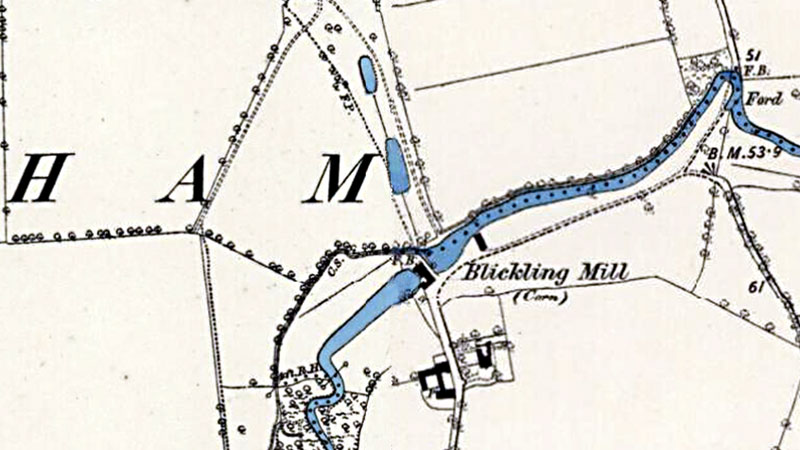
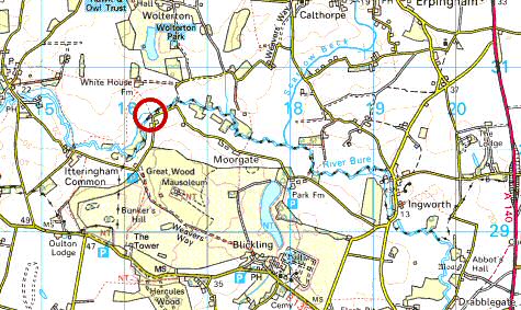
A document in The National Archives at Kew shows that Blickling mill burnt down at some time before the summer of 1559 - the first year of Queen Elizabeth’s long reign. The fire may even have been that year - a mill was an important and valuable resource which would not have been left in disrepair for long. That summer it was rebuilt, apparently from the ground up, by Sir James Boleyn, then lord of Blickling manor and resident in the old Blickling Hall. To do work on the new mill foundations, the course of the river had to be diverted away from the mill temporarily. This was achieved by digging out the silted up old course of the river. The document makes clear that ‘in old times’ the river Bure had been the parish boundary between Itteringham and Blickling all the way along the stretch upstream from the mill until the sharp turn at its closest point to the back entrance now to Blickling Woods. Nowadays though, a part of Blickling parish appears to lie on the Itteringham side of the river, bounded by what seems to be merely a drainage ditch. That ditch had been the river; diverted probably in early medieval times to its new course to create a stronger flow and more continuous supply of water through the mill. The old river course could be used as a run-off route at times of flood. Perhaps when diverting the stream, they had wanted to create a large mill pool or dam all on Blickling manor lands. More practically, the lie of the land lent itself best to a long thin and deep dam gaining some height relative to the position of the wheel rather than an enlargement of the original river itself. This would have achieved greater water force through the wheel. Perhaps also, wanting to build a much larger mill, they needed to set it on firmer and slightly drier ground just a short distance away from the original course of the river. The mill does sit just at the end of a long section of meadows naturally set above even the winter water levels. Downstream the land on either bank is very low and boggy. No better site for a mill could be envisaged along this long stretch of the river. The two water courses and meadow in between can be seen clearly on the 1823 enclosure map. The extract from the Itteringham map held at the Norfolk Record Office shows White House Farm at top left and the back entrance to Blickling woods just off the map bottom left. The red line (original to the 1823 map) marks the parish boundary where it differs from the winding course of the river. The mill pool or dam is straight, long and wide. The 1881 Ordnance Survey map, available online from www.old-maps.com, also shows the mill pool, but the old river course simply looks like a field boundary. The red line on the enclosure map really helps us to understand what had happened. On the ground one can see why the new river course was chosen. The meadows on the Blickling side of the river are noticeably higher than the land on the Itteringham side. The straight mill dam was created simply by building a long bank on that side, relying on the natural lie of the land on the Blickling side to contain sufficient volume of water. Although the dam has been narrowed by the growth of reeds, the high northern bank is still visible and intact. 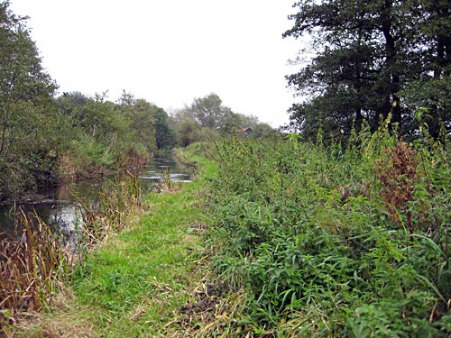 Looking towards the Mill along the Narrowed Dam with the Overgrown High Bank on the left The bank is particularly noticeable at the bend where the dam diverges from the old course of the river. Today the old river course still just about flows along its again overgrown and silted ditch. 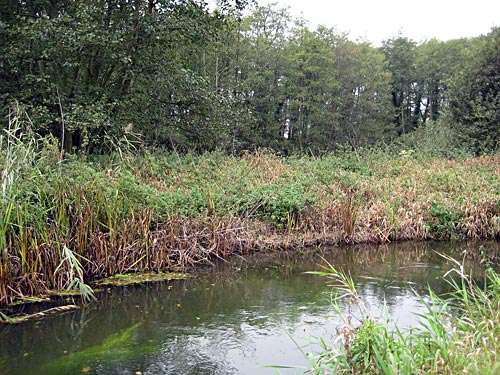 The River Bure looking North at the Bank Cutting off the Old River Course As a parting note, it is interesting to see on the enclosure map that the whole loop of the nearby oxbow was taken as the parish boundary, with the land within it being in Blickling parish. This implies that this was a very ancient loop in the river, predating the emergence of parish boundaries perhaps in late Anglo-Saxon times. It could not have been a medieval or later creation, even if then it was used as a fish trap. Today one can walk along the Blickling bank of the complete oxbow. Silted up ditches at either end show some evidence that there had at one time been a ditch across the neck of the bow enabling a fish trap there. |
Copyright © William Vaughan-Lewis 2007 |
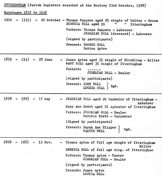 |
Ayton & Bell marriages |
 |
 |
|
Headrace
March 1967
|
Headrace
6th November 2002 |
|
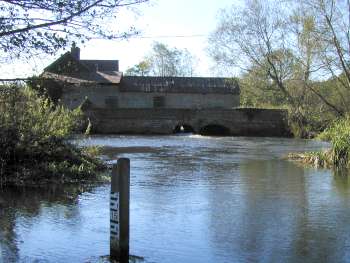
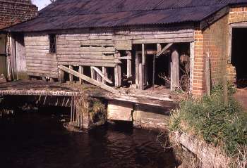
Unusually, the two sluices are housed in leanto section at the back of the mill that was probably a late addition to protect the sluice operator and the sluice gates from the elements. One gable end is of brick but the majority of the structure is dark stained weatherboard with a corrugated iron roof. The sluice system itself is fairly basic and of an early design that would have allowed for repairs and maintenance by estate workers. |
 |
 |
|
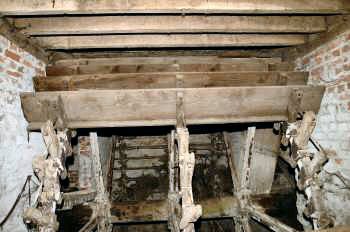
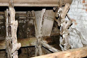
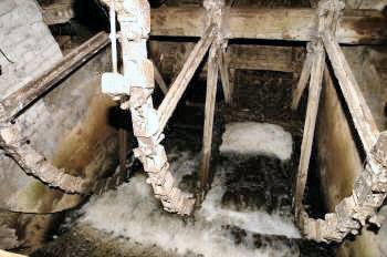
Remaining
waterwheel paddles 6 November 2002
|
Waterwheel
6 November 2002 |
 |
 |
|
Wheelrace
6 November 2002
|
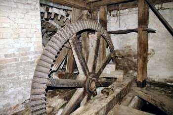
Pitwheel
6 November 2002 |
|
After milling production ceased in about 1914, the wheel axle was direct connected via flywheel pit to a three cylinder horizontal water pump that was used to pump water for cattle troughs in Blickling Park and this possibly continued until the 1950s when the pump was given away for scrap. The pump was housed in a weather boarded leanto shed built against the wheel house gable end. After pumping ceased the shed was used as a garage for a time before being demolished due to being unsafe. One of the mill stones was later found in poor condition in the garden of Mill Farm. |
|
By 1977 the lower paddles of the waterwheel had been removed in order to facilitate the flow of the river and prevent blockages in times of flood. The wheel had six cast iron bolted spokes on a wooden axle. The pit wheel remained intact and one of the stone nuts was partially buried in the floor. The building was not in a very safe condition and was being used as a junk store. |
|
In 1979 the Anglian Water Authority put forward a propsal for a water gauging station that would have involved reconstrucion of the rear of the mill and the removal of the old sluice gear. Although plans were drawn up, it appears the project was eventually abandoned. By 2002 very little has changed except the building had been made safe. |
 |
 |
|
18th April 2007
|
30th June 2004 |
 |
O. S. Map 1885 |
 |
|
O.S. Map 2005 Image reproduced under licence from Ordnance Survey |
|
1559: Mill destroyed by fire but rebuilt in the same year
Kelly's 1883: Benjamin Cook, also Itteringham Mill Kelly's 1896: Walter Bell, miller (water) & farmer Kelly's 1900: Walter Bell, miller (water) & farmer Kelly's 1904: Walter Bell, miller (water) & farmer c.1912: Mill ceased production Kelly's 1912: James Nelson Edwards, farmer, Mill Farm c.1930: Upper two weatherboarded storeys removed 1979: Anglian Water Authority proposed a water gauging station but it was not built 2004: National Trust holiday cottage and junk store |
If you have any memories, anecdotes or photos please let us know and we may be able to use them to update the site. By all means telephone 07836 675369 or
|
| Nat Grid Ref TG 16323041 | Copyright © Jonathan Neville 2004 |