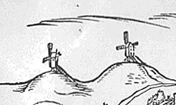
Pockthorpe Hassett's mill
& Pockthorpe St. James Hill mill
1558 map
1558 map
|
Pockthorpe
Hassetts postmill |
|
|
Pockthorpe Hassett's mill
& Pockthorpe St. James Hill mill
1558 map |
|
There was a
windmill outside the Barre Gates by 1328. Barre Gate was also known as
Pockthorpe Gate. |
 |
|
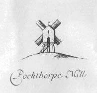
1696
map
|
|
This sunk post
mill was marked on the 1558, 1611, 1696 and 1723 maps. On the 1696 map
it is marked Pockthorpe or Hassets Mill. A map of 1718 appears to place
the site of the mill roughly where the later Pockthorpe smock and tower
mills stood, or it may indicate a post mill stood before the smock mill. |
|
To be SOLD |
|
An accident to a Pockthorpe resident, which involved a millstone is included here for interest: |
|
CASUALTY, On Thursday, as Jeremiah Marshall, of Pockthorpe, was assisting
in getting a large mill-stone upon a drug, it ran back and fell upon his
thigh, the bone of which it crushed in so shocking a manner that he was
obliged to be immediately carried to the Norfolk and Norwich Hospital;
and from the very humane and liberal attention which is always paid to
distressed object by that very benevolent institution, there are great
hopes of his doing well. |
|
The mill was destroyed in 1787. The rebuilt Pockthorpe mill only lasted eight years before being burnt down on Thursday 16th April 1795. |
 |
|
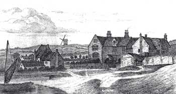
Hassets
house and mill 1791
drawing by Henry Ninham |
|
On Thursday night last, about twelve o'clock, a windmill on Mousehold,
near the Barracks, was perceived to be on fire - very soon the whole was
in flames and totally destroyed before the least assistance could be given.
The effect of the light upon the surrounding objects, and the stillness
of the night, rendered the scene awfully grand. A mill in the same place
was destroyed about 8 years ago, and we are sorry to hear this was not
insured. |
|
Although the mill was marked on maps of 1797 and 1826 there is no other evidence that the mill was rebuilt after the fire of 1795. The 1797 map was surveyed between 1790 and 1794 and thus would have shown the earlier mill. The 1826 map could have simply copied the 1797 map and marked the mill, a common practice at the time. It was not marked on the 1830 map. |
|
Cuningham's map: 1558: Windmill Thursday 16th April 1795: Mill destroyed by fire |
| If you have any memories, anecdotes or photos please let us know and we may be able to use them to update the site. By all means telephone 07836 675369 or |
|
Nat Grid Ref TG24000975
|
-1328+
-1558 to 1787, 1787 to 1795, 1795 to 1826+?
|
|
| All
historical material within this page © Michael Roots & Jonathan Neville |
Web
design and website © Jonathan Neville, Norfolk Mills 2004 |