1696
map
|
Aylsham Road
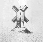
St. Augustine's Gate postmill |
|
|
1696
map
|
|
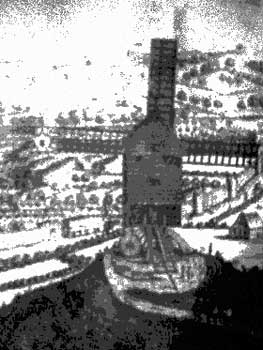
St Augustine's Gate mill, just off the Aylsham Road was marked on a map of 1675 and was often known as Green Hills mill. It was also marked on the 1696 and 1723 maps as well as on a map showing the owners of land adjoining the river Wensum made by John Rumball jnr. in 1767. The mill was marked on the 1834 map as standing to the South of St. Clement's Place. The site lies between Patterson Road and Eade Road, close to Aylsham Road. |
 |
|
1723
map
|
|
A Mr. Robertson was the miller in 1773, when the mill was robbed on the 8th February |
|
On Monday night near 60 fowls were stolen from Mr. Robertson, a miller
near St. Augustine's Gates. |
|
On Thursday, an inquisition was taken by John Roach, Gent, Coroner,
on the body of Robert Dickens, about 14 years of age, who being of a weak
capacity, had inadvertantly wandered too near a Windmill then going, just
without St. Austin's Gates, by one of the sails of which he was struck
with so much violence just above the right ear, that after being conveyed
to the Norfolk and Norwich Hospital, he languished a few hours in an insensible
state and then expired. |
|
There was a robbery near the mill on the Monday 16th January 1832 |
|
On Monday night last, between nine and ten o'clock as a young man
by the name of Mann, who lives in King-street, was returning home from
Mr. Thompson's, who lives about three quarters of a mile on St. Augustine's
road, he was stopt near the mill by two villains, one of whom had on a
white duffield coat, the other a dark velvet, with very large white buttons
in front. One collared him and demanded his money, while they rifled his
pockets, but finding nothing they took off his hat and rent it nearly
in two, and the flail basket off his arm; being dissapointed they struck
him a violent blow on the breast, knocked him down, and kicked him when
on the ground, and then decamped with the basket into Mr. Gowing's field. |
|
William Goodwin may have been the miller in 1832, when he died in September of that year |
| DIED. Lately at Mill Cottage, St. Augustine's Road, Wm. Goodwin Esq., aged 73. Norfolk Chronicle - Saturday 6th October 1832 |
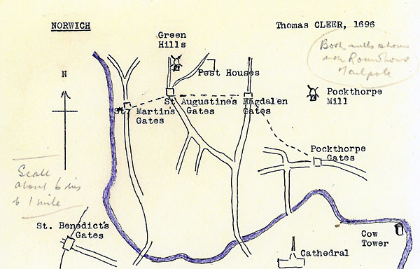 |
Cleer's Map 1696 as redrawn by Harry Apling (incl. hand written notes) Pockthorpe mill stood on what was then Mousehold Lane |
|
Ogilby's Britannia map 1675: Plate 74 and Plate 76 - Windmill |
If you have any memories, anecdotes or photos please let us know and we may be able to use them to update the site. By all means telephone 07836 675369 or
|
|
Nat Grid Ref TG22800985
|
-1675
to 1834+
|
|
| All
historical material within this page © Michael Roots & Jonathan Neville |
Web
design and website © Jonathan Neville, Norfolk Mills 2018 |