Wiveton
postmill


Wiveton post windmill stood on the southwest side of the village.


The map of Blakeney & Cley Haven of 1586 shows a windmill to the southwest of the church.


Grant by Thomas Smith, millwright, of Wiveton to John Smith, millwright, his son (on John's marriage to Mary Emery, widow) of all his cattle, corn, working tools, implements of husbandry, household goods, and personal estate.
1722

The 1735 - 1736 Profit Accounts of Henry Calthorpe, Rector of Blakeney mention four accounts of rye and wheat to Rayner ye Miller at Wiveton.


Briston, June 17, 1779

To be Sold ...
Also a WINDMILL with its going Geers and about one Rood of Land, situate in Wiveton in the said county.
For further particulars enquire of Thomas Mendham of Briston aforesaid, of whom Money may be had on approved Mortgage Security.

Norfolk Chronicle - 19th June 1779

Sale advert 1784
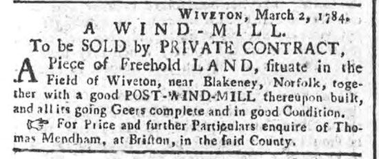
Norfolk Chronicle - 6th March 1784

All maps place the mill in a broadly similar location, west of Wiveton church.
The 1586 map shows the illustration further to the south (south west) compared to the church, than the 1797 map but is difficult to place as only one road is shown. The layout and orientation of the village is very different to the 1797 and present day map.
The map shows no building close to the estuary, which in 1586 would have been a busy port at that time. If an inaccuracy in the 1586 map is assumed and the village buildings, church and mill were all rotated clockwise, the rough positions would more closely match the other two maps, placing the mill in a similar location as on the 1797 map and move the buildings closer to the river. (Observation of existing buildings to the north of the current Blakeney Road are old and low-lying and would have been along the edge of the estuary.)
However, if it is assumed that the relationship of road and village are correct and the road shown is the line of the current Blakeney road, it would indicate that much of the southern village has now disappeared and building to the north of the road took place after the map was produced.
This would then indicate the presence of an older mill in a different location in relation to the road and church to the 1797 map.
The 1797 map places the mill on the north side of the Wiveton - Blakeney Road, to the west of an adjacent track leading from the Blakeney road to a section of a distinctive figure of eight shaped piece of road in Wiveton village.
Physical Observation of Location.
A public footpath/bridleway from the Blakeney Road to the same section of Wiveton village roads is shown on the O.S. Explorer 24 Norfolk Coast Central 1997.

The corner of the field bordered by the public bridleway to the east and the road to the south is accessible, with a slightly raised area initially but the field has a general slope away from the corner. The location is high in comparison to lands to the northwest/east. It is open with views over towards Blakeney and Cley churches. No physical remains or other indications were immediately obvious or found. The field is cropped. It might reveal further evidence by aerial inspection. This location would catch prevailing winds and would make a good site for a windmill.
Anne Grand - 3rd June 2008


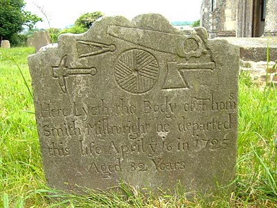
Gravestone of millwright Thomas Smith - died 16th April 1725

Millwright Thomas Smith, died 1725 has a grave in Wiveton churchyard. The headstone states millwright and is illustrated with tools of the trade.
Information inside the church suggests he was a miller owner/miller. However the information is aimed at children and may not acknowledge the difference between a millwright and a miller.
The Explore the Churchyard sheet from inside Wiveton church states: "Can you find four ancient graves in a row? They are graves of one Wiveton family called smith who lived here for hundreds of years (until 1920). One of them owned the mill in Wiveton and ground the corn into flour for local people. His gravestone has all the tools of a millwright carved on it.
"
Anne Grand - 3rd June 2008

Index of Wills 1723: Francis Smith, millwright of Wiveton


Maritime map 1586: Windmill

1722: Thomas Smith passed all his business and personal effects and estate to his son, John Smith

December 1724: Francis Smith, millwright, died

16th April 1725: Thomas Smith, millwright & miller died at the age of 82

Henry Calthorpe Accounts 1736: ? Rayner, miller

Norfolk Poll of Freeholders 23rd March 1768: John Smith, Wiveton, miller

June 1779: Mill advertised for sale

March 1784: Mill advertised for sale by private contract

Faden's map 1797: Wiveton Mill


If you have any memories, anecdotes or photos please let us know and we may be able to use them to update the site. By all means telephone 07836 675369 or

Nat Grid Ref TG03954300
Top of Page

Copyright © Jonathan Neville 2008