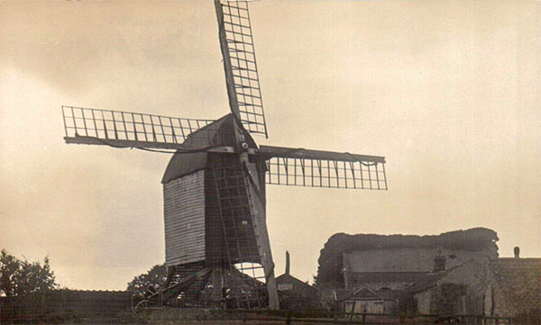
Southery
postmill


Contact

Drainage Mills (Windpumps)
Steam Mills
Watermills

c.1890
Mill working c.1890

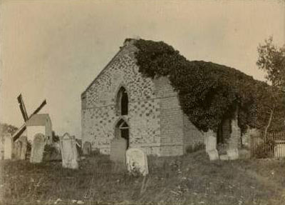
Southery post mill stood just to the north of the ruined St. Mary's church in the village in Mill Lane. The mill was an open trestle mill powered by 4 common sails and was turned to wind with a tail pole. The 3 storey buck had a felt roof.


c.1916
c.1916

Faden's map of 1797 shows the mill on the south side of the church, which means that either the map was drawn incorrectly or the mill was moved by the time the Ordnance Survey map was drawn in 1824.


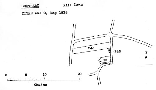
Tithe map 1838 - as redrawn by Harry Apling

Tithe Award 1838
Map 1838
Owner: William Reeve
Occupier: do

No. 245
No. 246

Mill & Yards
Pightle

Yards etc.
Pasture

0a. 1r. 0p.
1a. 2r. 2p.
-------------
1a. 3r. 2p.

£1. - 6d.


To Millers
Wanted immediately, a steady Single Man to take charge of a Post Wind Mill. To board and lodge in the house. Liberal wages given.
Apply to Mr. R. G. Reeve, Southery Mill, Downham Market.

Lynn Advertiser - 12th, 19th & 26th September 1874


SOUTHERY, Norfolk
CHARLES HAWKINS
Is favoured with instructions from Mr. Robert George Reeve (in consequence of his having taken a business in another part of the county) to Sell by Auction at the Bell Inn, Southery, on Wednesday July 28, 1886 at 6 for 7 o'c in the evening, an excellent

BUSINESS PROPERTY
Comprising brick built and tiled Dwelling House ... good garden, post wind mill, flour dresser, wind shaft, break wheel, nuts, hopper and all going gears in good working order; enclosed cart, turf and coal sheds, two loose boxes, piggeries, fowls, containing in all about 0a. 2r. 0p. abutting east upon the Church road, north upon property of E. W. Harlock Esq.
Apply to the Auctioneer, Downham Market & Bank Chambers, Kings Lynn or to
Reed & Wayman,
Solrs. Downham Market.
Lynn Advertiser - 10th& 24th July 1886

After the mill was demolished a bungalow was built on the site and became known as Hill Top.


O.S. Map 1886
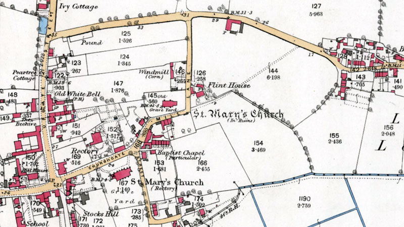
O.S. Map 1886
Courtesy of NLS map image

White's 1864: William Cook, farmer


Ogilby's Britannia map, London to Kings Lynn 1675: Windmill

Faden's map 1797: Windmill

Poll Book 1802: Samuel Elmer, miller

O.S. map 1824: Windmill

Bryant's map 1826: Windmill

White's 1836: William Reeve, corn miller

White's 1845: William Reeve, corn miller

White's 1854: William Reeve, corn miller

1856: William Reeve, miller

1858: Mrs. Harriet Reeve, miller

1863: Henry Cook, miller

White's 1864: Hannah Cook, corn miller & baker

1868: Henry Cook, miller

1872: Henry Cook, miller

1872: Robert George Reeve, miller

White's 1883: Thomas Reeve, corn miller


1886: Robert George Reeve, miller

July 1886: Mill advertised for sale by auction

O.S. map 1886: Windmill (Corn)

White's 1890: Thomas Reeve, corn miller


O.S. map 1890:
Windmill (Corn)

Kelly's 1892: Robert George Reeve, miller (wind)

Kelly's 1896: George Register, miller (wind & steam) & butcher

Kelly's 1900: Robert Reed, miller (steam & wind)

Kelly's 1904: Robert Reeve, miller (steam & wind)

Kelly's 1908: Robert Reeve, miller (steam & wind)

Kelly's 1912: Robert Reeve, miller (steam & wind)

Kelly's 1916: Robert Reeve, miller (steam & wind)

Kelly's 1922: Robert Reeve, miller (steam & wind)

O.S. map 1983: Windmill


If you have any memories, anecdotes or photos please let us know and we may be able to use them to update the site. By all means telephone 07836 675369 or

Nat Grid Ref TL62279480
Top of Page

Copyright © Jonathan Neville 2011