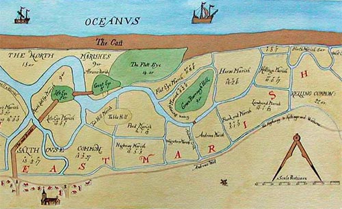
1649 map by John Hunt; redrawn by Val Fiddian - mill bottom right of centre
Image section reproduced from www.salthousehistory.co.uk
Image section reproduced from www.salthousehistory.co.uk
|
Salthouse postmill
|
|
1649 map by John Hunt; redrawn by Val Fiddian - mill bottom right of centre Image section reproduced from www.salthousehistory.co.uk |
|
Salthouse postmill was an open trestle mill that stood to the east of the church and to the south and above St Andrew's Wall. |
|
The Description of Salthouse and Kelling Marishes in the County of Norff: as they were Imbanked and Divided into Common and Severall inclosures, Anno Dom. 1648 and 1649. |
|
John Hunt's map 1648-1649: windmill |
If you have any memories, anecdotes or photos please let us know and we may be able to use them to update the site. By all means telephone 07836 675369 or
|
| Nat Grid Ref TG08004370 approx |
Copyright © Jonathan Neville 2007 |