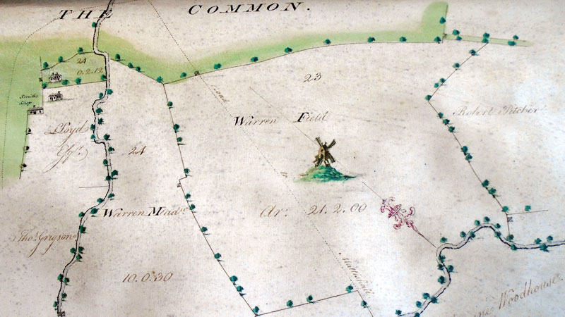
Thomas Warren's map 1776
The open trestle postmill is cleary shown in Warren Field to the west of the watermill
Courtesy of NRO
|
Hardingham
postmill |
Hardingham postmill was shown on Thomas Warren's map of 1766 and Faden's map of 1797. The open trestle mill stood in Warren Field, also known as Warren Piece, to the west of the watermill. |
Royal Exchange Fire Insurance policy 87116 |
Jas. Smith of Hardingham in the County of Norfolk, Miller. On Furniture in his Dwelling House, Thatch'd, sit. in Hardingham aforesd., £120. Apperal in the same, £30. Utensils & Stock in Trade in the Water_Mill stud & tiled, £270. Utensils & Stock in Trade in the Stables Sheds thatch'd adjoining, £50. Utensils & Stock in Trade in the Windmill in the Warren Piece near, £30. 31st July 1783 |
The postmill was replaced by a towermill c.1820. |
|
Thomas Warren's map 1776 |
 |
Thomas Warren's map 1776 |
July 1783: James Smith insured the mill's stock & utensilsl for £30 with Royal Exchange Fire Insurance c.1820: Postmill replaced by a towermill. |
If you have any memories, anecdotes or photos please let us know and we may be able to use them to update the site. By all means telephone 07836 675369 or
|
| Nat Grid Ref approx TG0460161 |
Copyright © Jonathan Neville 2022 |